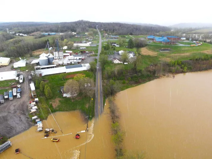
Grayson County Emergency Management has released an updated list of roadway that are either closed or soon will be.
“If some of these roads are not underwater yet, they will be shortly. Some water may have receded, but with the projected forecast, they will probably flood again,” GCEM said.
The forecast for the remainder of Friday is not calling for significant rain. On Saturday, though, the National Weather Service is forecasting a 95 percent chance of rain for the region, particularly during the afternoon hours. Expect roadways where floodwaters have receded to again flood with the additional rainfall.
Grayson Co. roadways closed or expected to be closed in the near future
Pleasant View Road at the 2300 block — Higgs Road at the 700 block — Bloomington Road at the 3500 block — Pine Knob Road at the 2000 block — Barton Run Road at the 1220 block — Old Fat Bruce Road — Caney Creek Road at the 4200 block – Wilson Church Road at the 4800 block — Dog Creek Road at the 2000 block — Richland Road at the 100 block — Clagget Road at the 488 block — Mulberry Flats Road at the 1261 block — Hooper Barton Road at Bear Creek — Mt. Zion Road between 1367-1904 — Sadler Lane at the 1700 block — Bowling Green Road at the Edmonson County line — Olaton Road at the 2-3 mile marker — Cave Mill Road at the 1836 block — Caneyville Cutoff Road at the 1700 block — Sunbeam Road at the 3525 block – E. Maple St. at the 500 block (Caneyville) – N. Main St. at the 102 block (Caneyville) — Post Hopewell Road at the 1000 block — Gibson Road at the 600 block — Lilac Road — Ready Jackson Road — Watershed Road — Buck Creek Road — Hornback Road — Mahurin Cemetery Road — Cummings Road — Millerstown Road (several locations) — Edward’s Cemetery Road — Blackrock Road — Clifty Church Road — Huffman Road — Neafus Road — Pleasant Run Road — Linwood Estates
If you come into contact with flooded roadways, please contact Central Dispatch at 270-259-0303.
U.S. Army Corps of Engineers letting water out at Rough River Dam
“Due to the Louisville District, U.S. Army Corps of Engineers letting out water at the Rough River Dam, downstream could rise more than usually expected,” GCEM said. “We have looked through the inundation maps from them and have made a list to include but not limited to affected areas. These will be in the Falls of Rough and Caneyville areas. These are broad areas and are not exact, nor 100 percent accurate. Just a reference.”
Jenny Green Road & Green Farms Road area — Diamond Branch Road — Lone Hill Road (particularly areas closer to the river) — Lone Hill Road and Owensboro Road – Owensboro Road in the area of Spring Fork – Olaton Road & Owensboro Road (Hites Falls Area) — Cane Ford Road area – Olaton Road in the Browns Creek area — Beaver Dam Road and Richland Road area – Beaver Dam Road and Neafus Road area – Beaver Dam Road and Dog Creek Road area.
“Again, the dam is not failing. This is a measure to control levels on both sides of the dam. If you have any questions concerning this, please contact the Louisville office of the U.S. Corps of Engineers.
For more information, click here.
WK Parkway
The Western Kentucky Parkway at the White Mills exit, while not closed (as of 7:45 p.m. Friday), has standing water in the roadway, and is down to only one lane in each direction. Use extreme caution if you must travel on the parkway, as at least one vehicle lost traction due to the high water and slid into a ditch.
(Headline photo: Flooding on Hwy 62 in Caneyville near Caneyville Elem. School)

By Ken Howlett, News Director
Contact Ken at ken@k105.com


